« July 2001 | Main | September 2001 »

August 2001 Archives

August 1, 2001

Damper and Topography

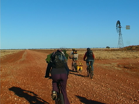
Part of the reason why damper was such an ideal food to live off on the
goldfields was partly because of the geography of the region. The early
diggers had to carry enough food for 6-months into the Palmer River.
And
because the area was so remote, it made sense to carry food that was
cheap, lightweight (for its nutritional value) and easy to cook.

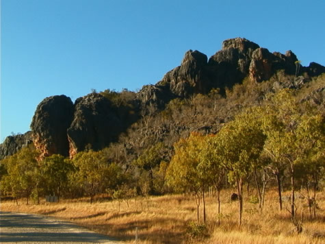
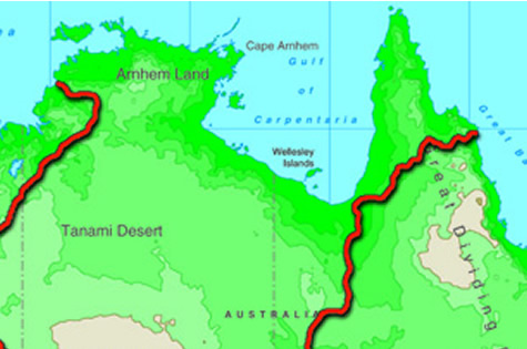
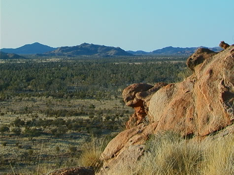
The Palmer River region is in the Great Dividing Range of mountains
that
stretch north/south from the tip of Queensland thousands of miles all
the way down to bottom of Victoria. The mountains are formed by the
convergence of two tectonic plates called the Tasman Fold Belt and the
Australian Craton - that are pushing up the earth's surface to produce
mountains.

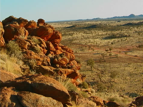
The early diggers would have had to pass over the Great Dividing Range
from Cooktown to reach the Palmer River. Without a road the trip would
have been extremely hazardous. Apart from the severe relief, they would
have also had to deal with loose rock and shale that characterize the
region. One bad foothold could mean serious injury.

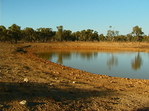
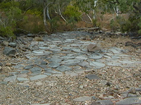
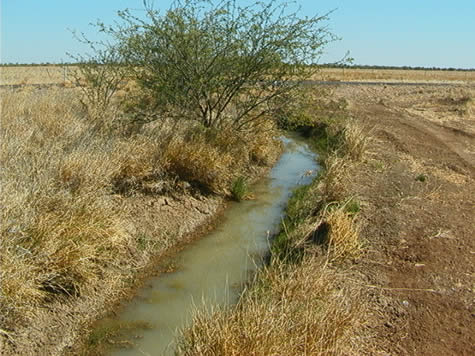
Being the watershed for rainfall draining both to the Pacific Ocean (to
the east) and the Gulf of Carpentaria (to the North), the Great
Dividing
Range is home to many rivers. During the wet season, the level of these
rivers would rise considerably, making crossing them too dangerous. So
the early diggers would also have had to contend with the problem of
returning to Cooktown before wet season set in.

Question: can you think of any mountains or rivers where you live than
influence people's lives? How are their lives affected? Are they
positive or negative influences?

Jason

August 2, 2001

Wrotham Park cattle station

Wrotham Park cattle station – Sam’s home – is 1.3 million acres in size. That the same size as Belgium!

Being east of the Great Dividing Mountain Range the ground is gently undulating with creeks (rivers) criss crossing the landscape. In winter (May-October) most of these will dry out completely. Dams are built in the dry season to store enough water from the wet season onwards.

The optimum ratio is 1 x cow to 60 acres. What does this tell you about the land?

The soil is very poor in this area meaning the little vegetation that grows here is not particularly nutritious. This means a very extensive farming technique is being used to raise cattle.

Suggested learning activities:
- Using an atlas, see if you can work out how many times your country fits into Wrotham Park Station – or visa versa as the case may be. Draw a map showing the relative sizes of both with the smallest drawn inside the largest of the two.
- List three main differences between intensive and extensive farming.
- Can you think of why dams would be an effective way of storing water in this area. Can you think of any disadvantages?

August 5, 2001

Exploring the Chillagoe Limestone Caves

2001 August 5, Sunday. Pinnacle Springs Station.

The old rail line snakes through the bush seeking a flat route, dodging between high granite rock piles, which balance incongruously above the landscape, and avoiding the networks of tributaries to the Tate River. Their beds are so dry and sandy it’s hard to believe they were streaming rills just four months ago, and will be later this year, as the wet season approaches again.

limestone_outcrop.jpg

Further north the way from which we have come, the granite gives way to limestone and instead of large rounded boulders in piles, jagged limestone monoliths jut from the flat landscape. Peaks as sharp as razors adorn the peaks of outcrops hiding labyrinthine caverns.

The area surrounding Chillagoe is protected by a National Park, which contains hundreds of caves. Limestone is soft, and water penetrates it easily, quickly causing erosion, and leaving the incredible system of tunnels which lie there today.
I took advantage of our rest day in Chillagoe to explore the Royal Arch Caves section of the National Park, using a candle to journey deep into the barren darkness. Nothing can grow inside the caves, because it is so dark. Aboriginal rock art can be found on the peaks above them.

Far down under the earth, moisture seeps from the walls of the caverns, carrying minerals from the sandstone into the air of the cave, where it hardens again. When drips fall from the ceilings of the caves in the same place for a long time, they leave sticks of hardened minerals behind, called stalactites and stalagmites. The two kinds “grow” toward each other from the roof and the floor of the cavern, until they meet and join, and a strong pillar forms which appears to be supporting the cave. These formations can become, over thousands of years, very beautiful and elaborate.

See if you can find out what kind of rock lies under the ground where you live. Have you ever been in a cave? Ask your parents and teacher if they have visited caves. What did they see in there? Bats often live deep inside dark caves, and come out only at night. What else can you think of that might like to live in a cave? Would you like to live inside a cave? Why or why not?

bel

August 7, 2001

Open Earth Tanks

There are two important questions that need to be asked in the construction of open earth tanks. Why not dams, and how do you decide where to build an open earth tank?

dam_dirt_and_treeline.jpg

Tanks are not dams. Dams are a construction where by you blocks an existing waterway and tanks are an excavation into which water is diverted. Because tanks only collect a small amount of the water that goes through the waterway, controlling the excess is a vital factor. This is done by the way of constructing earth banks to divert the water initially and then constructing a “bywash bank” which ends on higher ground to allow the tank to fill and the excess water to return to the natural water-way. Unlike a dam that can effect the ecology above it’s trapping point as well as the flow below, the open earth tank does neither of these things and is only used for one purpose. That purpose is to maintain the livestock’s need for water during the dry season.

Due to the huge flow of water during the “wet” dams could not control the water that flows down to the plains nor is there a need for the farmers to try. Tanks remain the most effective way for farmers to water their live stock with out being to intrusive to the natural environment around them.

The second question is how you decide just where to build an open earth tank. The first requirement is to select a strategic area on the station, which is deficient in water for the stock to be able to make use of the natural vegetation. The next requirement is to find a waterway that is sufficient to fill your tank. Sometimes these waterways can be surprisingly small. Next an open flat area is required to accommodate the excavation which can use up to a two acres. Then the trick is to construct the tank in a spot that it will fill easily and the water is not to hard to control.

The open earth tank provides livestock with life maintaining water through the “dry” season in an environmentally non-intrusive way.

John

August 9, 2001

Communications & Settlement

Today we followed communication lines that have served the needs of the people living out here in the remote outback for the past 150 years.

natural_pavement.jpg

- In the beginning there would have the old coach-road built and used by Cobb and Co. This was partly visible today snaking back and forth beside the new sealed one. The stagecoaches would have brought in mail and essential supplies to the communities along its route.
- At the turn of the century a railway was built (just to the south) to transport ore, cattle and passengers to and from markets.
- The telegraph line beside the road would have provided people with communications with the outside world. One major benefit was the ability to communicate with medical services in an emergency.
- The modern sealed road we rode on today brings tourism dollars to the area and a way for the dreaded road-trains to get from A to B.

communications_tower.jpg

Suggested learning activities: Find out about a major road in your area and research its history. Was it always a road? How would it did it affect your community once built. Were the effects positive or negative? Explain your answer.

Jason

August 12, 2001

Maps

2001 August 12, Sunday. Between the Gulf Developmental Road and Flinders Highway, NW of Malpas Station.

Cycling in the Far North of Australia can potentially be a dangerous undertaking, but even when driving out here, you need to be aware of hazards. Our support truck has its own adventures negotiating the backroads to meets us with supplies. The land is largely untamed and water supply is sparse. Wildlife can be a danger if you do not know how to handle a surprise encounter.

Tourist Maps of the areas we are passing through have many warnings on them for the benefit of travellers who are unfamiliar with the countryside:
“NOTE: Entry to some Aboriginal Communities is restricted and may require approval in writing from the community council.”
“WARNING: Swimming in tropical waters in summer can be dangerous due to marine stingers. Always seek local advice.”
“DANGER: Track conditions are subject to frequent change. Creek crossings are generally unimproved and often difficult to negotiate.”

crister_joshua_gps.jpg

Other interesting things marked on our maps include Ghost Towns, vast salt pans and marsh land, sand ridges, swamps, caves, ruins, and hundreds of kilometre long roads marked simply ‘surface unspecified’. Relentless erosion owing to the torrential rainy season, can change the condition of unsealed roads at an alarming rate.
Much of the land is changeable, and even with recent maps, it is best to ask locals for advice on the areas you are about to enter. Dry and temporarily dry rivers and lakes are common, and it is difficult to know whether you will face an impossible deluge, a dry, sandy depression, or a lovely clear swimming hole. What can appear to be a town on a map might turn out to be only a small homestead.

What types of things could you mark on a map of the area where you live, which might be unusual to people from different parts of your country, or from around the world? What similarities might there be? Does the land change around the year? Do the roads change? What warnings can you think of which you could tell a tourist who was driving to your house? What could you tell someone who was going to ride their bicycle to your house?

bel

August 14, 2001

Landscapes

2001 August 14, Tuesday. 45 kilometers North of Julia Creek.

The Great Dividing Range borders the east coast of Australia and shelters the infinite plains which stretch virtually unbroken to the west coast. From the vast Nullabor across the Great Australian Bight in the south, through the Great Sandy desert in the Red Centre, to the Gulf Savannah Grasslands where we have made camp this evening, the land is extraordinarily, uniformly, flat.

jim_biking_long.jpg

Today, the insignificant undulations we had cycled across, and which provide drainage for rainwater, petered away gradually, and fell into a floodplain. The trivial alteration in ground level was not enough to discern with the naked eye, and the land is parched at this time of year. However, it could be seen from the vegetation, and the signs of cattle hooves having sunk into the earth at some stage, that tremendous amounts of water once drained into the area. The utter absence of trees of any significant height within eyeshot, suggest that it also spent a lot of time draining into the clay subsoil to join underground reservoirs.

Throughout the trip we have crossed a great many rivers and flood ways – dry and otherwise – but none so interminable as today’s, which stretched for over thirty kilometres, leaving us yearning for shade. The view was unimaginable – reaching endlessly to a mirage scattered horizon.

How far into the distance are you able to see from your bedroom window? How far can you see from your yard? What eventually blocks your view – hills, trees, or buildings?

bel

August 16, 2001

Geography of Burke and Wills Expedition

australia_map_cut.jpg

The coast of the Gulf of Carpentaria includes some of Australia’s wildest and most remote country. Before early explorers returned from the area with tales of unparalleled hardships, a plan existed for the coast to harbour a busy port, trading with the wealth of Asia. However, the terrain made any such plan an impossibility.
The Gulf coast is interlaced with hundreds of drainage channels carrying wet season rains away from the flat country farther inland. The flatness of this inland terrain causes the water to sweep across the plains in sheets, or thousands of tiny rivulets, rather than being directed into one or two major rivers. In mountainous country, rivers run only into each other. Here, the land is so flat that water can and does flow out into two or more forks from the one source. This constant fanning out of watercourses, combined with a sheltered coastline and a tropical climate, results in a twisting, jungle lined delta – utterly inaccessible by an overland route to this day.

Burke and Wills discovered at first hand just how challenging (and at times just downright impassable!) the gulf country could be, most notably in the wet season. They were even prevented from completing the last 6 kms to the ocean because of their path being blocked by mangroves. Imagine how frustrating this must have been having just walked 1100 kms! They took the tidal flow in a nearby river as proof of completing their mission – to reach the sea – before turning around and heading back again..

The following is an excerpt from Alan Moorehead’s ‘Coopers Creek’.

“They had struck the wet season; day after day the warm rain poured down, and the camels hated it. They foundered around in the boggy ground, moaning and groaning, and Billy the horse grew very weak. Something like 170 miles still divided them from the sea, and they followed the Cloncurry River downstream to the point where it joined the Flinders River….by the end of January they had reached the Flinders River, and were moving slowly down the Byrno, which was one of its outlets to the sea. The mud was frightful.”

Suggested learning activities:
- research other examples of flood plains either in Australia or another country. Make a comparison between how rivers behave in a flood plain versus a mountainous terrain. Draw pictures where appropriate.

August 22, 2001

The Artesian Basin - Origins of Water

Geography
22 August 2001

The Great Artesian Basin has had an effect on both the way humans and many animals live in the Outback. For humans it has been a reliable source of water in an area where nothing but hot summers are guaranteed. Sure, reservoirs are built out here to hold the huge amounts of water that fall during the wet season, but what happens when there’s a drought? The water that is stored in the reservoirs can also evaporate well before the summer rains begin again. The Basin is a huge pool of water below ground that can be tapped by wells and accessed anytime of the year. With this almost guaranteed supply, the risk of not having enough water to raise cattle in this area is reduced significantly. Stockmen in this area of the country are able to raise many more animals and are primarily limited only by the amount of food available from the land. The Basin is also the main water source for many of the towns that exist in this part of the Outback.

open_chan_irrigation2.jpg

The troughs of water that the stockmen provide for their cattle help other animals as well. Kangaroos can maintain larger families because of the availability. Flocks of budgerigars (budgies) and other birds can find more places of refuge than they could before people began tapping the water below and bringing it up to storage areas above.

In other arid and semi-arid parts of Australia, away from the Great Artesian Basin, water is often the most limiting factor for the existence of any life, whether human, animal or plant.

Suggested Learning Activity:
Find out where your water comes from.

August 23, 2001

Northern Territory

The sign said ‘Welcome to the Northern Territory of Australia: Nature Territory’ as Mike and I passed, leaving behind Queensland and crossing into the Northern Territory. A contrast between what we’ve left behind and what we have to look forward to seems in order.

bel_terr_border_sign.jpg

The area of Queensland at 1,727,200 square kilometers, makes up 22% of the Australian continent. Green, productive lush rain forests, fields of sugar cane, and national parks on the east between the Great Dividing Range and the Coral Sea, give the tourist industry an outlet to the Great Barrier Reef. To the west of the Great Dividing Range, vast areas of agricultural land rich in volcanic soils comprise the tablelands.

Perhaps the region that we’ve spent the most time cycling through is the vast outback that lies inland. It fades into the Northern Territory to the west. Rain can make this arid region bloom, but it’s a land of sparse population, long empty roads and tiny distant settlements.

We’ve seen examples of the collection and storage of water from the Great Artesian Basin, created over a period of 2.5 million years as water gradually seeps westward from the Great Dividing Range. It fills approximately 7500 artesian wells that provide the only source of continual water for huge cattle stations. The Wet season does provide a variation on this theme as countless dry river beds become swollen creating a network of waterways which can make travel impossible.

biking_with_windmill.jpg

By contrast, the Northern Territory makes up 17% of the Australian landmass, an area of 1.35 million square miles. Although about 80% of the Territory is in the tropics, as the Tropic of Capricorn bisects the continent north of Alice Springs, only the northern 25%, known as the Top End, resembles a tropical climate. There, savannah woodlands and occasional rainforests are in direct contrast to the desert, semi-arid plain in the southern three-quarters to the south.

Today we have slipped through the door to the Northern Territory. Alice Springs, to the southwest, awaits us as we journey toward the Red Centre.

Suggested activities: Compare regions where you live, i.e., climate, temperature averages, rainfall, topography. Investigate the reasons why these regions vary in contrast to each other. Identify mountain ranges and plateaus, which influence rainfall amounts. Discuss how is agriculture affected by climate and what types of crops/livestock are grown near you.

August 28, 2001

Geology & The MacDonnell Range

The MacDonnell Range we entered today is a freak of Australian geography in so much that it is the only mountain range in Australia that runs east west. All the other ranges run north south.

rocky_huckitta_view.jpg

Approximately 850 million years ago a shallow sea covered the whole area. Then approximately 600 million years ago the range was formed from the flat land sliding vertically during land movement.

During heavy rainfalls, water carves the rock causing widespread erosion over the mountains, leaving amazing rock formations through the range. If the rock hadn’t been washed away over the years the MacDonnell range would be about as big as the Rocky Mountain range in Canada.

Feed your children wheat. Joshua.

August 29, 2001

The Huckitta Land System

Wednesday 2001 August 29. North of Claraville Homestead.

Having passed the ‘Huckitta’ Station turn off earlier in the day, it was interesting to learn that the foothills we are now entering is called a Huckitta Land System.

“The Huckitta Land System of rugged limestone ranges in the central part of Australia covers about 1600 square kilometres. Its steeply dipping and often contorted limestone hills reach a height of up to 225 metres.”

rocky_huckitta_outcrop.jpg

Climbing a few of these rocky hillocks yesterday evening gave a terrific demonstration of how the aspect (direction a slope faces in relation to the sun) even of small dry hillocks, impacts the vegetation which will grow there. The sunny side of a hill (in Australia this is the north) is hotter and drier than the slope which is shaded during midday heat. This is true for mountains thousands of metres high, right down to large boulders on relatively flat land. Liverwort will assert itself on the hospitable side of a rock only, and it is possible to find direction by observing this.

The shaded side of a slope causes a number of environmental conditions to vary. Some of the most noticeable include the amount of precipitation received, the change in humidity levels, the temperature difference, and the amount of solar energy available. Different plants thrive under these different conditions.

Over many years, larger amounts of water and sunlight have an effect on soil composition, by encouraging organic matter to grow and break down in the earth, enriching it, and increasing the variety of plants able to grow in those areas.

Think about how your household’s food scraps (organic waste) is disposed of. If you have a garden, suggest to your parents that you begin composting. If you have a compost heap already, find out how it works, and who maintains it. Adding compost to your garden will allow you to grow plants including vegetables which otherwise would not thrive in the same space.

bel.

About August 2001

This page contains all entries posted to Australia Lesson Activities - Geography in August 2001. They are listed from oldest to newest.

July 2001 is the previous archive.

September 2001 is the next archive.

Many more can be found on the main index page or by looking through the archives.

Powered by
Movable Type 3.35