« Overland Australia - Update 66 | Main | Overland Australia - Update 68 »
October 16, 2001
Overland Australia - Update 67
October 16
Day 85

‘Decisions’
John - “Expedition 360, this is BlueDog. Anybody read?”
Jason - “BlueDog. This is Jason. Reading you loud and clear. Over”
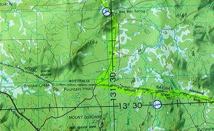
John – “Yeah, it looks like the track running up to Mt Ringwood station is a go. A bit ‘sloppy’ from the rain they’ve had here recently according to Warren, the manager here at Ban Ban Spring, and Bill from Mt. Ringwood who I just spoke to on the phone. Slippery, but doable – a slow road though”
Jason – “BlueDog, thanks for that. Did either of the two managers give you any idea of the track? Whether it’s the quartz, sandy stuff we’ve been on, or soil?”
John - “Ah, more bull-dusty soil than sand. It’s also the flood plain for the Adelaide River, so there’s quite a bit of water lying about apparently”. A short pause, then…
Jason – “BlueDog. Sounds like a bit risky to me, especially given the clouds building as we speak. There could be some more rain this afternoon and we can’t afford getting bogged at this late stage, not that far from the highway anyway. Even though it sounds like a pretty interesting track to explore, to be fair on Mike I think we need to play safe and head for the highway.”
John – “Roger that. Also, Warren said there’s a lot of water buffalo in the area we’d be passing through. He got chased on a motorbike by one for about 4 kms the other day and he reckons they’d make short work of a push-bike rider!”
The closing stages of any leg of the expedition are always fraught with logistical dilemmas . Past ocean crossings have been especially challenging: pedalling into the island of Tarawa in July 1999 for example involved the consideration of a complex dynamic of factors such as tides, prevailing wind direction and speed, direction of currents etc, to ensure actually hitting the island rather than being swept straight past into the empty void of the west Pacific.
Making it safely through the Great Barrier Reef this time last year to finish the Coral Sea crossing with April was an even more hair-raising affair with an essential rendezvous with a support boat a few miles outside the Reef necessary to avoid the pedal boat being smashed to pieces.
Pedalling these last few days into Darwin are quite stress-free in comparison, but are not without their moments as I found out this morning in determining the best route north to Darwin. Desiring not to pedal any more kilometres on the bitumen that we absolutely have to, our plan from Pine Creek has been to pedal up the old dirt roads running parallel to the main paved Stuart Highway.

This idea has worked fine until mid-morning today when we were presented with a decision on whether to risk attempting a remote section of station tracks up through Ban Ban Spring station and Mt Ringwood station – two relatively isolated cattle properties about 75 kms east of the main highway - or to play safe and take the bitumen north.
The bottom line we have in any such decision making process is to ensure a safe arrival into Darwin this Friday morning at 09.00 hrs to allow Mike sufficient time to get airline tickets and a visa extension sorted out before the weekend.
With six other sweating, panting cyclists standing out in the rapidly increasing mid-morning heat, an early decision on such matters is always appreciated, assuming of course that it’s the right one! In the split second before recommending to John that we return to the relative safety of the highway, these were some of the factors that ran through my head: - we have approximately 200 kms to pedal in 3 days. This means a minimum of 70 kms a day – a figure we can easily do on bitumen or on a good, unsealed road. On ‘slow’ tracks, such as the one leading from Ban Ban Spring to Mt. Ringwood Station, past history suggests we do more like 40-55 kms per day, well below what we would need to make Darwin by Friday morning. -
It has rained in the past few days, and could well rain again. Bull-dust soil sounds like prime-bog material when water is added, so a good soaking could mean the truck and bikes getting bogged for a few days, even a week. Added to which the track, on closer inspection of the topographical map, runs along side the Adelaide River – not an insubstantial body of running water – which would undoubtedly increase the chances of flooding and any river crossings becoming impassable should it rain. - If we do get stuck we’d be 75 kms from the highway, not a distance we could easily get Mike to the highway across should it start raining. -
Even though attempting the route through Ban Ban Spring and Mt. Ringwood would mean a far more interested end to our 4,800 mile, 88-day pedal across the Australian outback, we (and especially Mike) would probably be worrying too much about the Friday morning deadline to really enjoy the scenery and the ride. It’s never easy to make the ‘right’ decision. Such a definition is, of course, relative to the prevailing circumstances at the time, which can change very quickly. Part of me – and the rest of the team for that matter - felt great disappointment at not being able to finish the trip as it had been planned and for the most part, executed all the way along: that of taking the lesser travelled dirt roads, station tracks and avoiding the bitumen at (almost) all costs.
But, life has an uncanny knack of never allowing one to execute a plan perfectly. Mother nature always seems to stick her oar in at some point and remind us humans, as she did so often on my previous ocean crossings, that as her guests, we are subject to the irregularities of her fickle moods whenever and wherever we least expect them.
Jason
* Aboriginal place-names of the day:
MIRRIBANDINI: A Large Kangaroo Ripped Open a Dingo which was Chasing it and Threw it Down.
TALLEBUDGERA: A Man Bitten by a Shark
PARRAGUNDI: Distant Parrots
MONACHE: A White Cockatoo with a Red Tail
WOOLARK: A Black Cockatoo with a White Tail
WIRRAGULLA: A Parrot
CLASSROOM ACTIVITIES >>
Literacy
History
Geography
Posted on October 16, 2001 4:07 PM