« Selat Lombok crossed OK | Main | Harmony of Amed »
September 5, 2005
The Crossing
DAY: 83
LOCATION: Ahmed - Bali
NAUTICAL MILES TODAY: 0
NAUTICAL MILES YESTERDAY: 25
NAUTICAL MILES TOTAL TRIP: 766.5
LATITUDE : S 08 degs, 20.26'
LONGITUDE: E 115 degs, 39.50'
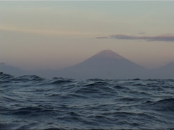
We left the south shore of Gili Trawangan at 4:20 a.m. to begin the crossing of Selat Lombok toward Bali. The day before, we had climbed the highest point of the island to look west across the selat thinking it might be a bit less intimidating if we could get a look at what we would be facing. Gunung Agung, the largest volcano on Bali, appeared in the hazy distance. Its eastern edge was to be our destination point, but to get there, we had roughly 25 miles of water that could potentially throw us a curve ball. Jason had gone over the Admiralty chart of the crossing with me, explaining the best and worst case scenario of what we might encounter. He'd studied this crossing extensively as this one was the biggest selat so far and it was alot of water where things could really 'go south' in a hurry. He'd determined that the earlier we got started, the calmer the conditions with current and winds, which really kick up as the day goes on. These selats also have strong tides running south toward the Indian Ocean, which could potentially drag us into areas with whirlpools and ferocious currents.
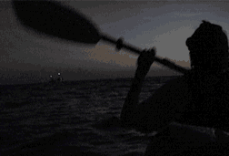
We left in darkness, using celestial points for navigation, making our way to the north end of the island. As we were rounding the corner, thunderous surf was breaking off the northwest coast. A warning light to ships gave off an eerie glow in the spray made by the breakers. I began to wonder how close we were, but at that moment, a sense of the strong ocean swell beneath the kayak let us know we had left the protected waters of the island. In addition, the lights of a cargo ship were bearing down on us off our starboard bow! Would they notice the nav light we had placed on Queenie? Our little light seemed awfully small in comparison! Luckily, the ship did see us and began to bear away. Holy cow, I thought. All of this and it's still an hour til sunrise when we get to actually SEE what's coming at us!

It was daybreak when the first big wave hit the kayak, washing over the top. Welcome to Selat Lombok, I thought. And, as we continued our westward progress, it seemed as if we were crossing a giant headland, filled with big waves similar to what Jason and I faced on the Coral Sea. Our magnificent "Queenie" rolled with the punches of each passing swell. We were getting hammered and I did wonder if there might be one which would roll her over.
The coast of Bali began to take shape as the definition of landforms became more evident, and luckily, the anticipated southerly current to drag us in the wrong direction hadn't materialized...yet. Our course was staying true and after nearly five hours of full-on paddling, we had made about half of the crossing. Land has a funny way of giving a false sense of security in its closeness. At eight miles out, houses began to take shape and shorelines become clearer. I watched my reference points, hoping that we continued on true course and Jason took continual readings on the GPS to confirm that we were.

With six miles to go, we hit a countercurrent which seemed to halt our forward progress. This was especially difficult as the water had begun to settle down as we neared shore, but the paddling had become a grind. It's at this point when you call on tired arms and shoulders to keep on keeping on. Jason called out, "We're not out of the woods yet!" Then a container ship, that didn't see us, had creeped up astern of us (at 15+ knots they can do that in a hurry if you're not looking in the right direction!) and we stopped just in time to give way. That's when we noticed the two sharks who had come up to give us a look. These were the first I've ever seen and "Crikey! They were enormous!" So, with that adrenaline rush, we pushed on toward the shore!
Nine hours and 25 miles later, we made landing on Bali's eastern shore. We had crossed the Wallace Line, the division between those islands of the east which broke away from the Australian plate and the islands of the western section of the archipelago which belong to the Asian plate. The transition is evident in the flora and fauna here in comparison to what we've seen. Selat Lombok was also a symbolic transition, opening the door to the next half of the archipelago for the expedition. But for the moment, I'll simply enjoy having that crossing behind us and look forward to what is to come.
Posted on September 5, 2005 6:31 AM
Comments
wow! great work, guys! i hope you slept well....!
Posted by: gl. at September 6, 2005 1:30 AM
Oooh, that sounds scary. Well done both of you. Hope you are both happy and well. Lots of love.
Posted by: astrid at September 5, 2005 10:46 PM