« Chaos on the Road | Main | Company on the Road (for a while) »
August 23, 2006
Map Lingo
Click on image to play video (high speed connection advised).LOCATION: Dali, Yunnan Province, China
SEE WHERE WE ARE!
Longitude: N: 27.51°
Latitude: E: 099.82°
Miles from Singapore: 2937
Check out a slide show of photos from Singapore to Dali uploaded just today -
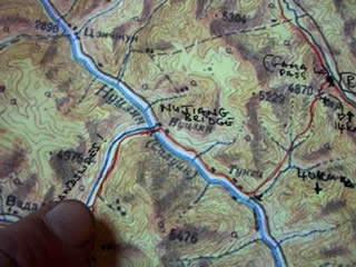
Much of the past few days layover in Kunming and today back in Dali have been spent poring over maps of the next section up into Tibet to Lhasa. It will be the most demanding part of this leg from Singapore to Mumbai, with over 1600kms of very rough terrain, often between 4,000 and 5,000 metres altitude, along a road that frequently dissolves into a muddy track for hundreds of kilometres at a time. It's the section that has been monopolizing my thoughts for over a year now. I reckon there's a 50/50 chance of making it to Lhasa on a first time attempt (for various reasons). And if I can make it to Lhasa, Mumbai is just around the corner.
The chances of success will to a large degree depend upon decent maps, and that's where it starts to get really interesting! I have reports from a handful of cyclists who have biked this section before and thoughtfully published their experiences - written in English - on the internet. But the best maps are actually Russian topographical ones. I was able to find an oversize printing outfit in Kunming to print out hard copies of digital files that my father kindly sent me (no questions asked on copyright - it's China!). Great, so I have detail of the terrain. But the cyrillic names of the towns and key physical features won't mean a thing in the field where all the signs will be in Chinese Mandarin and the local people will only know them in Chinese and...Tibetan? So we're going from Russian, to Chinese/Tibetan, to English. While I've been lucky enough to find English speaking Chinese to help translate from the Mandarin alphabet to English, the Russian to Mandarin has all been using latitude/longitude. But then the small scale 1:250,000 Chinese maps I'm using don't have lat/long. But a 1:1,000,000 version does, so there's another hurdle to jump through to transpose between these two maps.
Getting the picture here?
jason
Posted on August 23, 2006 2:45 PM
Comments
Fascinating journey. Thank goodness we have technology to be along for this ride.
Posted by: Steve Woolf ![[TypeKey Profile Page]](http://www.expedition360.com/journal/nav-commenters.gif) at August 25, 2006 9:43 AM
at August 25, 2006 9:43 AM
